A busy airport ramp is a complex place. Imagine a time-lapse film of all those frenetic movements: aircraft, passenger bridges, stairs, fuelling equipment, support vehicles, tugs, luggage carts operating in close proximity to each other. It’s easy to understand the countless opportunities for collisions.
It has been estimated that one accident happens on an airport apron on average every 1,000 departures, costing the global industry more than $10billion annually, and causing hundreds of thousands of injuries to people. But we will never know the true costs. Collisions with aircraft and specialist GSE incur disproportionately heavy repair bills and increased insurance premiums. Then there is all that attritional, low-level damage that is never recorded or claimed. And, of course, the considerable consequential losses due to delays, penalties, downtime and disruption.
Operating safety cultures on the ramp have been stretched by pressures for quicker aircraft turnarounds. Compared to other industrial environments, aprons remain relatively unregulated, with many companies working on the tarmac, all with their own safety procedures. The trend for more sub-contracting of ground handling operations and growing staff shortages have only added opportunities for inconsistent practice and human error.
Turning to Technology
Increasingly, operators are turning to sensors and sensing systems to put more “eyes” on the ramp that can lock in reliability and eliminate unpredictable financial losses. Sensors can provide accurate measurements and relentless operation to remove human error and provide real-time guidance and support for drivers and pilots. From simple sensor-based detection and measurement right through to ‘plug and play’ driver assistance systems, equipment can be fitted to existing equipment, infrastructure and vehicles without the need to invest in new machinery.
But airports are unforgiving industrial environments and must operate without interruption, even in the worst of extreme temperatures and weather. Selecting the correct sensing technology to remain available even in harsh conditions can seem daunting. The risk of false trips, due to dust, fog, rain or snow, is a legitimate concern that could lead equipment specifiers away from optical technologies, even at the sacrifice of more accurate measurement data.

Adding “eyes-on”
So, what kinds of “eyes” are best? The options range from relatively simple ultrasonic or inductive detection to laser distance sensors, LiDAR (Light Detection and Ranging), Radar (Radio detection and ranging) and the use of imaging cameras. Each has their own way of mitigating against environmental conditions, and investment involved varies from a few hundred dollars to many thousands depending on the level of accuracy, range and data integration required.
Let there be light
Laser distance and LiDAR sensors are frequently used for collision avoidance in outdoor industrial environments, including airports. They use optical time of flight (ToF) technologies to send invisible infrared light beams to an object and measure the time taken for them to be reflected back to the sensor.
LiDAR sensors send out multiple echoes to overcome the limitations caused through bad weather, bright light, dust, smoke or mist. SICK sensors use our unique HDDM+ technology to automatically filter out irrelevant reflections, such as from water droplets or dust particles, and reliably output the actual measurement signals. As a result, the risk of false trips and unnecessary stoppages is eliminated.
A laser distance sensor can be described as a one-dimensional technology – it sends and reflects light in a single beam to enable detection and measurement, whereas LiDAR sensing technologies use similar laser-based technology to create monitored fields either in a two-dimensional plane, or by creating several planes to monitor a three-dimensional scanned environment.
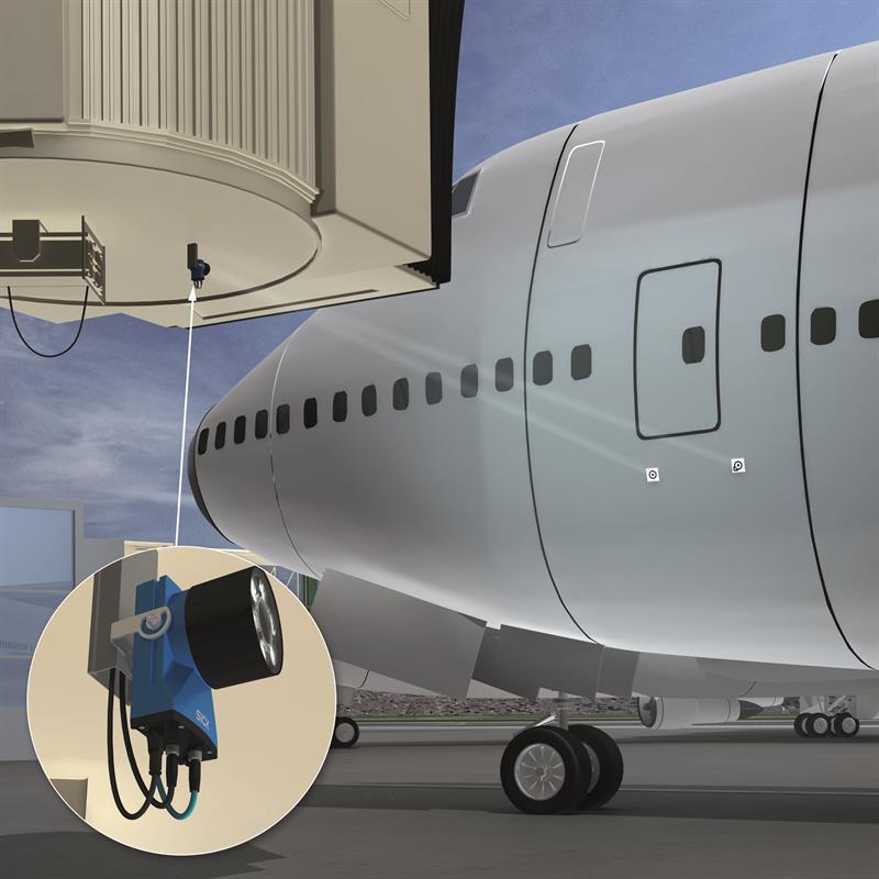
Passenger bridge docking is a common application where laser sensing technologies are used for collision avoidance. Single-beam laser sensors accurately measure the distance to the aircraft to aid manoeuvring, for example, or monitor the height of the bridge from the ground to guide safe docking.
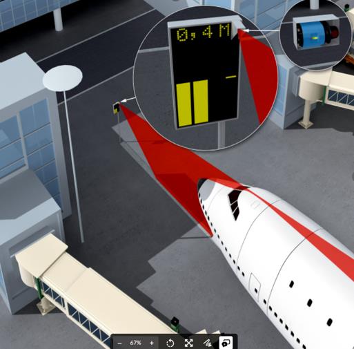
SICK’s LD-OEM 2D LiDAR sensor is used as part of a well-proven docking system for aircraft that provides in-cockpit support for pilots to park aircraft at the gate quickly and precisely. The sensor creates a vertical scanning plane at the ideal height in front of the aircraft so that the distance remaining to the parking position can be determined and shown on a display for the pilot in the cockpit.
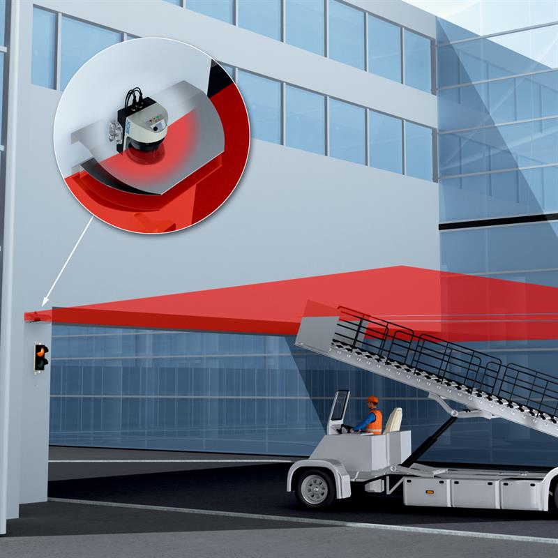
2D LiDAR sensors are used to create vertical fields that protect buildings or hangars, for example, or can control safe vehicle access into pre-defined areas. LiDAR sensing technology is sometimes integrated into safety systems, e.g. where emergency stop procedures are necessary to protect personnel. The SICK AOS Prime (Advanced Object Detection System) for example, combines a LiDAR scanner with a safety controller and incorporates sensor self-monitoring to avoid system failures.
It can be used, for example, to define a detection area around a passenger boarding bridge’s drive unit. If any of the several monitoring fields is violated, e.g. by a person, movement of the passenger boarding bridge is slowed or even stopped.
SICK has also developed the world’s first safety-certified laser scanner for outdoor use. Positioned on the bogie of a passenger boarding bridge, for example, the SICK outdoorScan3, allows for safe operation whatever the weather, with no additional protective devices.
Radar technology
Radar sensors work on similar ToF principles to LiDAR but they emit electro-magnetic radio waves instead of infra-red light. Radio waves are not affected by environmental conditions in the same way as light-based technologies, so radar sensors can be the ultimate, super-tough choice for collision avoidance, especially during the hours of darkness. SICK’s recently-launched RMS1000 radar sensor can achieve 24-hour detection performance with long-range resolution and distance accuracy. SICK’s radar-based version of the AOS object detection system is designed for situations where there is high potential for collision.
The key difference is that, while LiDAR scans in a 2D plane, radar emits its radio waves in a cone shape, which expands over distance. So, radar is less well suited to detecting small objects further away because of its longer wavelengths at longer distances. The RMS1000 performs exceptionally well, to identify, say, a person at 50 metres, or could be a better choice to scan a wider environment at longer ranges than an equivalent LiDAR scanner.
Vision sensors
Camera-based technologies are emerging to offer viable alternatives to LiDAR and radar in certain applications. One promising new ground handling application to aid GSE alignment to aircraft doors came out of an industry-wide collaboration with IATA, airlines, GSE specialists, and airports. The project aimed to standardise the use of adhesive target markers on passenger and cargo doors, with the creation of a new industry standard. The markers are used to help align GSE such as Passenger Boarding Bridges, service trucks or mobile stairs, as well as to align belt loaders or container loaders. The system uses SICK’s Inspector P 2D vision sensor to identify the markers and automatically level the ground equipment during docking.
For all kinds of driver-operated GSE from fire trucks to luggage carts or forklifts, manoeuvring and reversing are a frequent cause of accidents. Vehicle-mounted collision warning systems combine 3D LiDAR or imaging camera technology with an in-cab display to monitor the blind spots behind and at the side of a vehicle, helping the driver to avoid collisions. They can often be fitted to existing vehicles.
SICK’s Visionary B camera is an intelligent system that uses 3D ‘snapshot’ technology to give the driver with an accurate real-time 3D image in the cab. The system can capture the size and shape of stationary or moving objects and their distance from the vehicle within a six-metre range, then recognise and warn about different objects according to their importance.
Aircraft Protection System
SICK’s Aircraft Protection System (APS) is a specially-developed driver assistance system for aircraft towing tractors, which was developed and tested with Lufthansa LEOS GmbH tractor fleets at Frankfurt and Munich airports. Once the aircraft’s nose wheel is positioned on the tractor platform, a SICK LMS511 2D LiDAR sensor mounted at the rear scans the entire area under the aircraft in a vertical plane. The sensor first scans the wheels of the main landing gear of the aircraft, so that the system can determine the aircraft type by comparing it with known landing gear geometry. The driver selects the correct aircraft type from a touchscreen display. Then the driver is provided with full visual feedback and audible warnings to appraise the situation under the aircraft and identify where any objects of concern are to the left, right, or behind.
Future trends
In just a few years, all kinds of sensor devices have reduced dramatically in size and cost while being able to process more data. This has allowed the development of more software and application-specific systems to be developed that are easy to install and operate. In future, more systems such as SICK’s APS and Aircraft Docking Solutions should offer prospects of more standardisation to address hazardous operations on the ramp, reducing the risks of costs and delays for all operators.